Love in the Desert?

Day Eight

Arches National Park
Moab, UT
Founded: 1971

Total Miles Hiked: 10.5  (48.06 overall)

We’d arrived too late to secure a camp spot in the park, however the nearby city of Moab had a plethora of private campgrounds to choose from. After consulting our handy Fodor’s guide, we soon were on our way to the recommended Slick(Shady)rock campground. It had all of the typical amenities: small grill, shade, restrooms, office wi-fi, pool, hot tubs, showers. We may not be in the park, but we’d be living in luxury and leave smelling like delicate desert flowers. For however long that lasts.

We only had the one day in the park, so we made sure to wake up early to make the most of our time. Someone once told me that Arches NP is where you go to fall in love with the desert. Now, I’ve been living in the desert for over two years now and have only a mild toleration for an area that is mainly devoid of forests and streams. But, I wanted to give the desert another chance.

As always, we stopped off at the visitor’s center for our trinkets and usual chat with the Rangers at the information desk. We’ve yet to be disappointed by the advice of the Rangers, and this morning Steven and Emma were not about to break that streak. Rachel and I usually try and have a basic idea of what we want to accomplish in a park. How far we want to hike (usually about 10 miles per day) and what sights we would like to see (arches and some bighorn sheep, please). Steven recommend the full Devil’s Garden trail (with primitive loop), a restful afternoon out of the sun, a quick walk around Balanced Rock, and then to top it off with a sunset trip to the Delicate Arch. Emma was our go to for bighorn sheep questions. Where can we find them? Does she know where they are right now. Is she hiding them? Can she let them come out and play? We were informed that sheep sightings are still rare in the park, but to keep an eye out during the first three miles. Oh, Emma, I don’t think you realize how badly we want to see the sheeps!

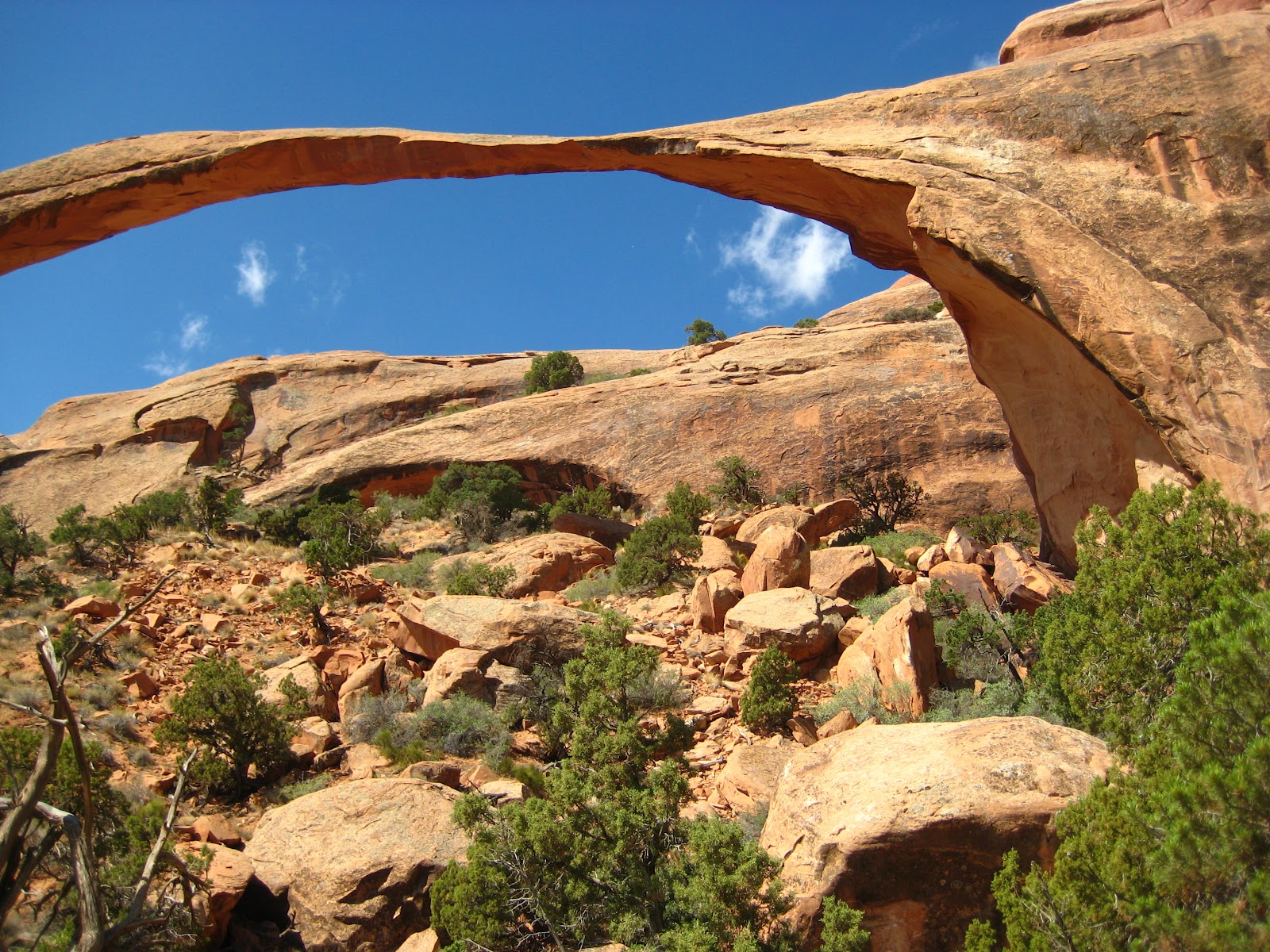
Landscape Arch. Can you tell where a slab fell?

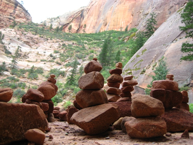
Our first trail was at the far end of the park, so we enjoyed the drive out by obsessively searching for sheep. Devils Garden is a trail that may be enjoyed at several different difficulty levels. Many of the arches available for viewing are towards the beginning of the journey directly off the gravel path. You may go as far as Landscape Arch, the longest in the park, before the primitive loop begins. Here, we were soon traversing and scrambling over rocks and ridges. Rachel’s choice of wearing a hiking dress that day was nearly a poor one, but she managed to stay decent. The crowd thinned as we encountered more and more arches and more and more difficult pathways. The rock cairns I explained yesterday were especially helpful on this terrain, and they often kept us on the right route.

We’d started off on the trail in the mid-morning hours, and were able to enjoy the cooler morning temperatures for some time. However, the desert is good at heating up once the sun is comfortable high in the sky. We aren’t ones to disregard park warnings, so we were well equipped with our water bladders in our packs, each holding 3 liters of water.

When we reached the end of the trail we were more than happy to have a rest and picnic in the limited shade we could find. Dark Angel looked over us as we munched our sammies and snacks. Then, once more, we were in the sun hiking back. Our second wind was more of a sweltering breeze due to the heat, and we were soon grateful to stand in whatever shady patch we could find. Despite the liters of water consumed, our hands were still swollen slightly by the time we reached the main trail again, a sure sign of the start of dehydration. The trail head and accompanying water supply were a welcoming sight.

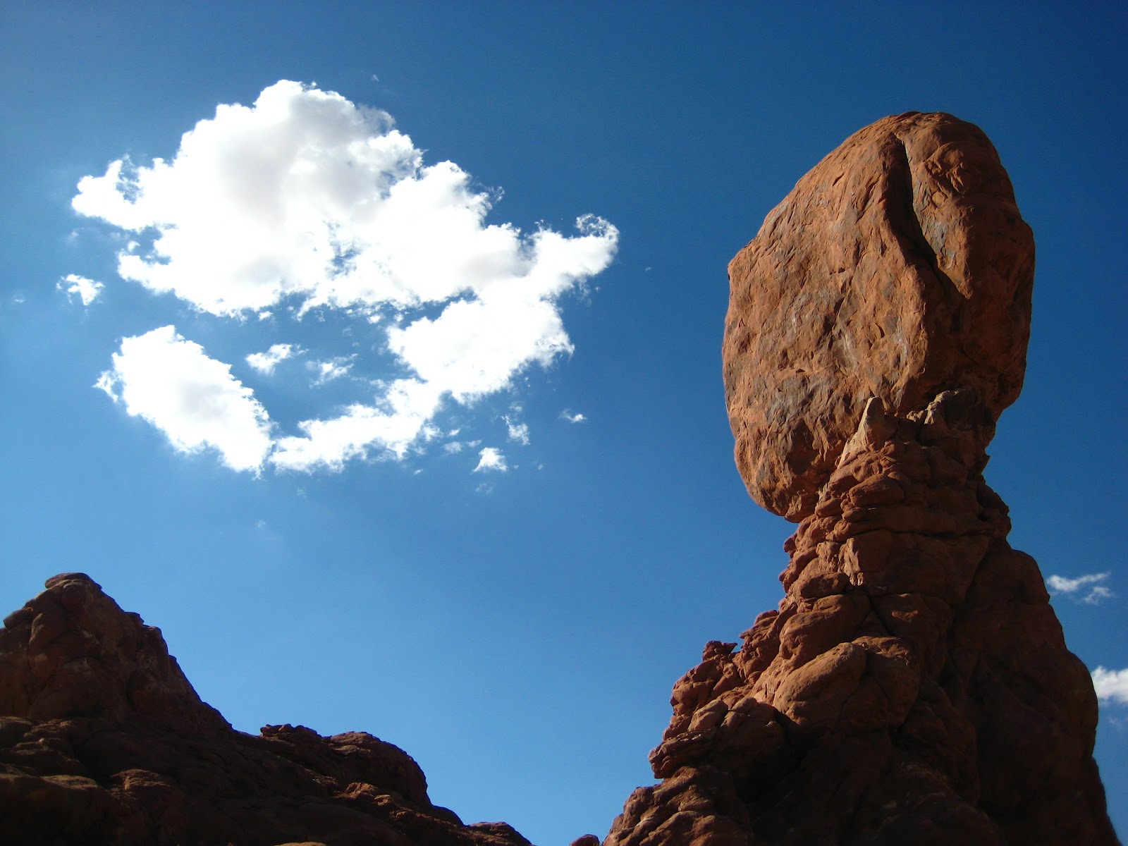
Balanced rock being all balanced and such.

We had plenty of time to spare before we needed to head out towards Delicate Arch for sunset and little desire to stay in the sun for much longer and, so, set out to find a place with shade to rest, write, and snack.

The picnic area across from Balanced Rock proved to be just the place for all of our needs. While most of the tables were in the blistering sun, we managed to score one with a lovely tree bending over to protect us with its shade. I tried to write some informative words for you, oh readers, but Rachel’s napping just looked so peaceful and I knew I wanted to join.

“Meridith….Meridith. Your face it in the sun.”

Rachel, once again saving me from certain cancerous doom.

To recover from our slumber, we got after some hummus with pita chips in a completely unladylike manner. But, it did the trick and we were soon back on the trails where we explored the mini loop around Balanced Rock before setting off for the Delicate Arch trail head.

We had plenty of time to meander along the route to the most famous of all arches in the park. We encountered the homestead of the first settler in the area. An Ohio man, who escaped to the West for the drying, presumed healthier, climate.  He built a teensy one room home for himself and his son. Later, when his daughter and her family joined them, he built a proper house with wood floors and everything. It was still teensy and perhaps had just slightly more space for the 4+ people than Rachel had when she lived in my laundry room senior year of college. Teeny tiny.

Continuing once more, ever closer to the final destination, we came upon what Rachel holds among her top 10 favorite things she’s ever seen. Petroglyphs on a rock above the trail. Perhaps as old as 400 years, these markings revealed horseback Ute Native Americans hunting bighorn sheep.  Small dog like creatures were also included. We were really impressed with the lasting power of the art and we walking on finally, still wondering about the markings that didn’t last the years and the individual who had sat there so long ago patiently carving the scene.

After some unexpectedly steep uphill climbs, we finally turned a corner and were presented with a sight we’d only seen in photographs, postcards, and nature documentaries. Delicate Arch. We’d arrived early enough to get a decent spot among the droves of people with the same sunset plans we had. It did, however, prove difficult to get a shot of the arch without a group of ridiculously posed tourists. The line of groups and families waiting to get that perfect picture under the arch seemed never ending, and if any stayed too long blocking the shots of other photographers wanting that solitary shot of the majestic arch, they were requested in no polite tones to move along.

We had both expected the sun to set behind the arch, however it actually slunk away behind our backs, drawing the shadows up over the arch from the bottom. Still a wonderful sight to behold. Several adventurous young sightseers took in the view from atop the nearby rock formations. The darkness grew, yet we stayed behind to enjoy the desert night. We were well prepared with jackets and headlamps, so felt no anxiety towards the upcoming night hike back to our vehicle.

The darkness welcomed us and we welcomed the sounds and sights of the nocturnal wildlife, awaking with the moon. We kept a slow pace so that everyone could pass us and take their noises with them. It’s always good to hear people enjoying the natural beauty of the parks, however many do not realize that the show is not over. It’s just starting. Once the night air was empty of these sounds, it began to offer up its own. We chose a spot on a small bridge over a pool of water. Day or night, water is a great place to find wildlife. We waited. It was not long until we were rewarded with the sounds of bullfrogs calling to potential mates, the flapping of bat wings as they whiz by us, and various insects chirping and humming. We listened and watched the stars come out before we said our final goodbyes to the park.

I don’t know if I’m in love with the desert yet. It’s still hot and often times not as elaborate or as colorful as Arches. Maybe I’m a little in love with shade in the desert, and that counts.

*more photos later – I can only do so much on stolen Yellowstone Staff wifi!*

Question of the Day:
What is your favorite type of landscape?

Lead the Way

Day Seven

Zion to Arches
Total Miles Hiked: 2.86 (37.56 overall)

Another day on the road and once more the scenery is gorgeous. It’s also really enjoyable to take in while going the posted speed limit: 80 mph! We had a lot of state to cover. Of the five different National Parks that Utah has to offer, Zion and Arches are the furthest two apart. Going from Z to A is a fresh change of pace. We were really beginning to appreciate Utah, maybe it has a bit of a bad rap due to the wimpy beers and excess salt in lakes. However, things started to get a little shady. We were in need of lunchtime refreshments and were desperately searching for a rest stop. Now, normally, every so often there are places you can pull directly off the highway, have a tinkle, stretch your limbs, and suck up some caffeine. In Utah, they are a little confused. After changing highways, we spotted a telling blue sign for a rest stop and exited. We were already looking around for the parking lot area, however we were quickly instructed via subsequent signage to continue back towards the highway we’d just left. 3 miles. To a gas station? The sign in front proudly announced the rest stop, sponsored by Cheveron. It was a Cheveron. Oh, Utah. You got us.

Ceder Breaks National Monument – meadow + forest
Photo by Rachel

Rachel’s Ramblings:
Have you ever gotten lost?  I’m guessing most people have.  However, I’m willing to bet that this happens to me more than the average bear.  I don’t know if it’s because I have a tragically bad sense of direction, or if I’m just too busy thinking about other things I have to do later, you know, after I achieve my destination.  In either case, I’ve been lost a fair number of times.  I’ve actually stopped calling it “being lost,” because that sounds too negative.  Now, whenever I find myself off the beaten path for some reason, I am “on an adventure.”

 
Leaving Zion – one last view of the sandstone walls.
Photo by Rachel

Lucky for Meridith, I took us on one such adventure when we were traveling from Zion to Arches.  But really, who wouldn’t want to pass back through Zion and see all those amazing sandstone formations one more time?  Basically, I got my easts and my wests a little confused and, BAM, our adventure had begun.  Lucky for me, after I gave Meridith many “I’m sorry”s accompanied by my best doe-eyed sad face she forgave me and saw the good in the situation.

 
Dixie National Forest – freshwater riparian area
Photo by Rachel

Our new path would take us through Dixie National Forest (http://www.fs.usda.gov/main/dixie/home)!  This is quite a large national forest (almost two million acres according to their website), and in the high elevations that we were driving through is dominated by aspen and various conifers.  This area is also dotted with many lakes.  Many of the lakes we passed were lovely with intact floodplains.  We admired the scenery of Dixie National Forest, about to be back on track when…the road was closed ahead, and we were redirected into Cedar Breaks National Monument.  At this point, we were just rolling with it. 

 
On the 70E in CO:  We crossed over those mountains 
and were uncomfortably close to the clouds.
Photo by Rachel

Cedar Breaks National Monument (http://www.nps.gov/cebr/index.htm) is an equally beautiful place to visit.  We drove through the high elevation forests, and saw some really stunning vistas.  I love high elevation meadows like the one pictured.  In front of all the meadows we passed were signs reading “Don’t Drive on Meadow.”  While that might seem like it would go without saying, it’s an excellent move on the part of Cedar Breaks to keep traffic off the meadows.  Subtle changes in elevation (like those resulting from foot traffic…or cars) can have major impacts on meadow ecosystems.  You might also notice in the right of the meadow pictures a stand of dead spruce trees.  We noticed this in Cedar Breaks and Dixie.  This is the result of the native spruce bark beetle which has reached epidemic proportions in recent years.  You can get the full story here (http://www.nps.gov/cebr/planyourvisit/upload/Why%20Are%20The%20Trees%20Dying%20Site%20Bulletin.pdf).  The current scientific theory is that a fungus is weakening tree’s natural defenses so trees that should fight off bark beetle infestation end up succumbing to the attack.  They are working on the problem, and increased scientific understanding is feeding directly into management action. 

 
After passing out of Cedar Breaks we were (finally) back on our original route and heading out of Utah and into Colorado!    

Getting lost while on a park trail is a major concern that you should keep in mind when hiking. Many parks have trails that are well developed and easy to follow. Other trails may be a bit more difficult to follow if they are a more natural terrain or if heavy weather is present. Some mountain trails experience white-outs that make things rather difficult to navigate. The current solution to this dilemma is about as simple as they get. You’ve probably already seen it and perhaps didn’t recognize the significance.

Rock cairns.

Or, rather, those silly little rock piles that you see everywhere.

They are actually handy little guides.

I’ve seen them lots to mark switch backs and overgrown trails.

Maybe if Zion had used them to mark the route to Arches we wouldn’t have gotten lost…I mean gone on a surprise adventure.


Question of the Day:
Have you ever been hiking a trail that used rock cairns? Did you know they were so helpful?

A Healthy Dose of Fear

Day Six

Zion National Park
Total Miles Hiked: 9 (34.7 overall)

A long rest was needed after the ups and downs of the previous day. The weather had cleared up enough for us to feel comfortable braving the Narrows. Even though we would be without the recommended walking stick. We took our sweet time puttering around South Campground in the morning. We realized we underpaid for the first two nights (access passes get 50% discount on campsite fees, not annual passes). We paid for one more night and the difference we owed, again careful to not upset any camping karma. We were nearly immediately rewarded when we noticed a Free Stuff Pile and there on top was a perfectly good, albeit slightly bent, walking stick! After another chat with the helpful Rangers Carolyn and Amanda, we were once more on the shuttle to the Temple of the Sinawava. 

Rachel’s Ramblings:

The Virgin River, and all rivers really, is a very powerful thing. 
As we rode the shuttle up to the trailhead, the soothing voice over the bus speakers told us about the many times the river had washed out the road causing evacuations and necessitating road repair.  Despite the many times this had happened, the voice assured us it would have happened a lot more if not for the work of the men of the Civilian Conservation Corps (the workers were segregated and no women ever enrolled).  Back in the 1930s and 40s these government workers came in and did hours of what was certainly physically taxing labor to secure the river banks.  This engineering of the river caused it to run straighter, faster, and kept water out of the historic flood plain and, thus, out of the road. 
Despite the good intentions of the CCC, all their hard work had unexpected consequences on the riparian ecosystem surrounding the Virgin River.  As our drive up to the trail head continued, the voice informed us that most of the cotton wood trees along the riparian strip next to the Virgin River were about the same age, and that is why we saw so many dead trees on the drive.  These trees were old.  You see, cotton wood trees need areas with near constant water sources to grow.  Even the fluffy seeds the trees release each year have to land on damp soil in order to germinate.  Due to the flood control measures enacted in the early 20th century, there are very few young cotton wood trees along this area of the river.
The shuttle audio didn’t go into detail, it was only a 30 minute drive after all, but this sort of change in riparian vegetation can have major impacts on ecosystems.  I’m not trying to bash the CCC.  It’s so easy to look at these sorts of situations with our modern eye and pass judgment.  However, I think Zion felt it important to share this story so that visitors could see how fragile these ecosystems really are.         
Still wide at the beginning of the trail.
Lots of sun.


We arrived. The paved beginning of the Riverside Walk was quite crowded with both hikers and crazy, in your face  canyon squirrels. Obviously one or two or a few hundred of the park visitors had disregarded the numerous postings about the importance of not feeding the wildlife. I saw small children walking right up to the rodents while their parents did nothing to protect them. No fear in these little guys. We continued along the river to the entrance.
 

We checked the skies once more before wading into the Virgin River for our adventure. Clear and sunny. No death via flash flood for at least a little while. Heading further up the river, the number of people thinned and the water deepened to our waists. Luckily, we are good little thinker-aheaders and had purchased dry bags before entering the park, so all of our day pack goodies were safe. Rachel, being the stream walking goddess that she is, decided I would benefit more from our karma walking stick. I completely did.

Our tiny sliver of sky for cloud watching.

The first three miles had periodic banks where we could escape the waters and tricky rocky bottoms for a nice stroll. Then back into the drink. After those initial three miles lay an additional two where we would be hiking in the river the entire time. This was where the danger zone really began. Clouds could roll in at any time upriver and release their torrents and we’d be subject to the results with little time to react. Only a tiny sliver of sky was viable above us, but we kept an eye on it at all times. Flash floods are a constant threat to hikers in the Narrows. If you can’t get to high ground, then your best bet it to try and wedge yourself behind rocks or cracks in the wall. 

Not the deepest we went!

We kept on. The water sometimes up to our waists. The rocks sometimes tricking our feet into thinking they were stable. Jerks. Even though I had the walking stick, I still took a few tumbles into the water while Rachel gracefully (well, more so than me) crossed back and forth over the river. I have to admit. The entire time we were hiking past the safe(er) zone I was looking for the best places to wedge myself (and Rachel) in case of a flash flood. It was much too lovely of a day to die in a furious barrage of water and tree detritus. 

Enthralled by the tadpolies.

Even with the fear of death, the walk proved to be a worthy endeavor. The sunlight tickled in every so often illuminating the impressive sandstone walls surrounding us. We hugged the walls every so often and were in awe of the colors, curves, and hidden treasures they offered. Some sections were shockingly smooth to the touch. We happened across pools teeming with aquatic wildlife that kept us enthralled for quite some time. Tadpoles darted about trying to eat up all the algal yummies so they could grow up to be big and strong with legs and everything. 

Rachel urged me further and further with the blatant lie of ‘let’s just check out what’s around the next bend’. There was even some veiled taunting, even it she may not admit it.

“Are you sure you don’t want to go as far as the old men?” RDW

I did want to go that far. Dang it. 

Our little bit of sunshine in the Narrows.

We kept on like brave explorers until we reached an area that we were informed would reach to nearly our chinny chin chins.

We looked at each other an a glimmer of understanding passed between us. We were brave, strong, adventurous women. We could handle anything.

And thus, we turned and headed back to the trail head. Even adventurous women need to know when to call it a day.

It ended up being a very solid decision, as we felt the first few drops of rain as we neared the area with the embankments. Once higher ground was within our reach, we both admittedly felt a surge of relief. There wasn’t a flash flood that day, but we were happy that we would’ve been safe had it been otherwise.

We emerged from the water once more victorious in our hike. The masses of people returned, as did the canyon squirrels. They would benefit from exhibiting the same amount of caution and fear as we had on our journey.

Question of the Day:
Have you even gone through with something, even though you were afraid? How did it turn out?